Cape Cod’s 399 square miles of terrain and 559.6 miles of coastline make the destination an idyllic locale for cyclists!
One surefire way to get the heart pumping and really see the Cape is the vast array of bikeways that are so beautiful. Hopping on a bike is one of the best ways to enjoy the natural beauty of Cape Cod - whether you are taking a mountain bike trail through marshland and forests, a ride on our scenic byways, or a cruise down one of our dedicated paved trails.
One surefire way to get the heart pumping and really see the Cape is the vast array of bikeways that are so beautiful. Hopping on a bike is one of the best ways to enjoy the natural beauty of Cape Cod - whether you are taking a mountain bike trail through marshland and forests, a ride on our scenic byways, or a cruise down one of our dedicated paved trails.
Jeanne's Favorite Rides
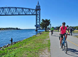
1. Cape Cod Canal - Ride on the Cape Side
Parking - Park under the Bourne Bridge - Directions.
Following the canal’s southern side for 7.5 miles between the Bourne and Sagamore Bridges. The bikeway itself is smooth concrete, with a bright yellow line painted down the center designating two-way traffic. It provides a fast, fun sprint.
Ride down to the Railroad bridge...then turn around and ride past the Sagamore. Bike around the Marina to the foot path. There is a rock jette that is lovely to walk out to the end. Perfect picnic place!
The bikeway itself is smooth concrete, with a bright yellow line painted down the center designating two-way traffic. Since there are not many places to park on the Cape side of the Canal path, most of the time you have the trail to yourself!
Additionally, a self-guided educational tour of landmarks is available for use. While on the trail, watch for numbers posted on navigational lighting poles running the bikeway’s entire length spaced out every 500 feet. A PDF companion Cape Cod Canal bike-hike guide is available (produced by the Army Corps of Engineers). Please note – this tour begins at the canal’s eastern end and ends at its western end.
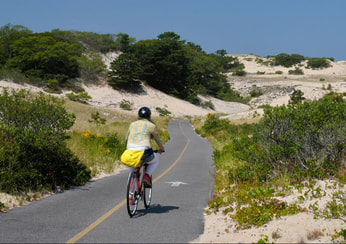
2. Ride the Dunes in Provincetown
This hilly loop starts from Province Lands Visitor Center in Provincetown. The route is 5.25 miles long. But with the trail extensions to Herring Cove Beach, Race Point Beach and Bennett Pond, two more miles can be added to your distance. Riding the trail is a great way to tour the vast dune system in the Province Lands area, as well as its shady Beech Forest, one of the few places within the tract with extensive tree cover.
The Visitor Center itself is an excellent source for more information on the history and current ecosystem of the surrounding area. It offers informative films, exhibits, a bookstore and the observation tower. Numerous Ranger-guided interpretive tours from the center also explore the dunes and hollows comprising this stark, but beautiful landscape.
This trail is a favorite for cyclists, even though the route can be challenging at times because of its undulating hilly terrain. The paved network traverses much of Province Lands’ 4,000 wild acres, winding through the quiet dunes of Provincetown and their unique coastal environment.
PARKING & DIRECTIONS
From Head of the Meadow Beach, travel Route 6 north toward Provincetown for six miles. Turn right on Race Point Road at your first stoplight. Look for signs marking the Beech Forest area and Province Lands Visitor Center. Race Point Road ends at Race Point Beach. To reach Herring Cove Beach, go to the end of Route 6.
Ample parking is available at the Visitor Center year-round. There are approximately 100 spaces in the front lot facing the observation deck and main building. Cyclists are encouraged to park here, as the trail begins at the top of the hill on the far side of the observatory. Route maps can be picked up at the trailhead entrance.
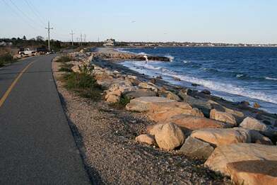
3. The Shining Sea Bikeway - Falmouth to Woods Hole
(SSB) was named for a line in the song America The Beautiful, written by Falmouth native Katharine Lee Bates. It follows the original route of the New York, New Haven and Hartford Railroad that used to run from Buzzards Bay, through North and West Falmouth, around Woods Hole and into Falmouth Station. In the early 1970’s the Town of Falmouth purchased the right of way, tore up the tracks and officially opened the 3.3-mile Shining Sea Bikeway in 1975.
In 2009, a new 7.4-mile section was added, extending the trail to North Falmouth. Now the SSB runs 10.7 miles from County Road in North Falmouth all the way to the Steamship Authority parking lot in Woods Hole (DO NOT EVEN THINK OF PARKING AT THE WOODS HOLE END). Download Map
Lined with familiar Cape Cod flower and tree species, it makes for a wonderful ride from Falmouth to scenic Woods Hole. Following the Old Colony rail line, the newer extension passes through Sippewissett Marsh, by cranberry bogs and overlooks Chapaquoit Beach. The entire route avoids much of Falmouth’s notorious summer traffic by winding along the coastline and crisscrossing the Salt Pond Bird Sanctuary.
PARKING & DIRECTIONS
To reach the Shining Sea Bikeway

4. Nickerson State Park
Located directly off the Cape Cod Rail Trail in Brewster, Nickerson State Park contains 8 miles of dedicated bike paved and mountain bike trails. Offering easy access to picnic area and campsites, this hilly and scenic network provides an enjoyable ride through beautiful pine and fir tree forests around ponds, lakes and bogs.
From Jeanne's house you can drive or bike over to Joe Long Road (there is limited free parking along this road). Here you can get access to the back side of the park. You can also go into the park (will have to pay to park here). Plenty of parking at the Camp Store.
Cape Cod Rail Trail (25-mile off-road paved path)
Download a Trail Map
Cyclists can follow the route of the old Cape Cod Railroad through six mid- to lower-Cape towns. The trail runs from South Yarmouth into Dennis, then winds through Harwich, Brewster (with a detour through Nickerson State Park), Orleans (through the beautiful Rock Harbor area), along a salt marsh to the Cape Cod National Seashore Center in Eastham and then to Le Count Hollow in Wellfleet. Several hotels, restaurants and attractions have Trail access. The name stems from the old railroad right of way it follows, which used to transport passengers and freight to Cape Cod in the early 1800s until around 1960. The route passes by many local points of interest and several lakes suitable for swimming and picnics, including Nickerson State Park in Brewster. Continuously monitored by local police bike patrols, the Cape Cod Rail Trail is a safe and enjoyable way to spend a Cape Cod summer day.
Cape Cod Bike Tour Website